VHF Connectivity In Himachal Forest Department
CASE STUDY: EXAMINATION OF VHF CONNECTIVITY BETWEEN SOME STATIONS OF HIMACHAL FOREST DEPAERTMENT
HIMACHAL PRADESH, a northern Indian state nestled within the Himalayas, boasts a landscape adorned with hills and mountains that span its entirety. SANCHAR COMMUNICATION SYSTEMS has received an inquiry from the HIMACHAL PRADESH FOREST DEPARTMENT to establish VHF communication links between several following stations.
| Sl. No. | NAME OF THE STATIONS | LATITUDE | LONGITUDE |
| 1 | Divisional Forest Officer, Killer Pangi, | 33° 4’49.91″N | 76°24’12.60″E |
| 2 | Range office at Hudan Bhatori | 33° 5’31.44″N | 76°28’19.53″E |
| 3 | Range office at Mindhal | 32°59’42.18″N | 76°25’39.73″E |
| 4 | Range office at Jhalwas | 33° 6’0.55″N | 76°23’3.36″E |
| 5 | Range office at SOCH | 33° 0’6.44″N | 76°26’38.69″E |
Objective: The primary goal of this “Field VHF Radio Link Survey” is to assess the feasibility of radio connectivity among these stations, situated in a region replete with numerous mountains that pose challenges to wireless signal transmission. Ordinarily, based on the principles of physics, radio waves, especially those in the frequency range above 30 MHz, propagate in straight lines, similar to the propagation of light or electromagnetic waves. In mountainous terrain, these radio signals encounter obstructions in the form of hills and mountains. However, owing to certain natural phenomena, these radio waves might undergo reflection from mountainous rock surfaces, irregularly finding alternative paths to their intended destinations.
Implementation & Results: To conduct this survey, Sanchar employed two concurrent methods: Software Survey using Google Earth (utilizing Google Earth to perform a virtual analysis) and Hardware Survey with Practical Demos (field survey team from Sanchar physically visited the sites to execute practical tests).
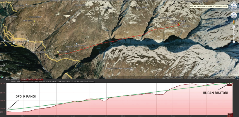
1) Line of Sight between DFO, Killer Pangi and Range Office Hudan Bhatori
Software Survey using Google Earth: It was found that the height of DFO, Killer Pangi is 2679 meters, while the height of Range Office Hudan Bhatori is 3646 meters above mean sea level. The aerial distance between these stations measures 6.79 kilometers. Google’s survey snapshot highlighted a direct VHF Line of Sight (LoS) between the stations, implying unobstructed connectivity. The outcomes from this software-based survey aligned with the results from the physical survey.
The connecting green line indicates the VHF LoS is clear.
Hardware Survey with Practical Demos: They deployed DRR extender units (model: G10Ui) at both stations and assessed communication using DRR handheld subscriber units (model: G5Ui) at each end. The results of these tests were remarkably clear, with crystal-clear voice communication achieved between the two stations.
2) Line of Sight Analysis between DFO, Killer Pangi, and Range Office Mindhal
Software Survey using Google Earth: The elevation height of DFO, Killer Pangi, was determined to be 2679 meters, while that of Range Office Mindhal was 2448 meters. The distance between these two stations measured approximately 9.76 kilometers. However, Google’s survey snapshot highlighted an unclear Line of Sight (LoS), illustrated by the sky-blue circle in the provided image. This circle indicated a major obstruction in the direct line of sight. Conversely, the practical field radio survey conducted by Sanchar’s site survey team yielded a successful result, leading to the representation of a clear line of sight with a green line. The possible explanation for this favorable outcome lies in the unique nature of the area, where VHF signals might have been reflected by adjacent hills on either side. Thus, due to these natural conditions, software predictions are not always accurate in hilly regions.

Hardware Survey with Practical Demos: Sanchar’s Field Survey team deployed DRR extender units (model: G10Ui) at both locations and conducted communication tests using DRR handheld subscriber units (model: G5Ui) at each end. The outcome was exceptionally clear voice communication in both directions.
3) Line of Sight Analysis between DFO, Killer Pangi, and Range Office Soch
Software Survey using Google Earth: For this scenario, the elevation of DFO, Killer Pangi, remained consistent at 2679 meters, while the elevation of Range Office Soch was 2571 meters. The distance between these two points measured 11.1 kilometers. Google’s survey demonstrated three locations marked by sky-blue circles, signifying obstructions in the Line of Sight (LoS). These obstacles, coupled with the greater distance (11.1 kilometers compared to the 9.76-kilometer distance between Pangi and Mindhal), led the Google survey to predict a lack of communication feasibility. Sanchar’s field survey team corroborated this prediction, finding an absence of Line of Sight during their on-site assessment.

Hardware Survey with Practical Demos: Sanchar’s Field Survey team placed DRR extender units (model: G10Ui) at both sites and tested communication using DRR handheld subscriber units (model: G5Ui) at both ends. Regrettably, the results indicated no success, with no signals received at either end.
4) Line of Sight Analysis between Range Office Mindhal and Range Office Soch
Software Survey using Google Earth: The elevation height of Range Office Mindhal was determined to be 2448 meters, while that of Range Office Soch was found to be 2571 meters. The aerial distance between these two stations measured 1.89 kilometers. Google’s survey indicated a clear Line of Sight (LoS), represented by the green line. Sanchar’s field radio survey team corroborated these findings, attaining the same successful communication outcome.

Hardware Survey with Practical Demos: Sanchar’s Field Survey team installed DRR extender units (model: G10Ui) at both Range Office Mindhal and Range Office Soch. Communication tests were conducted using DRR handheld subscriber units (model: G5Ui) at both locations. The results revealed exceptionally clear voice communication in both directions.
5) Line of Sight Analysis between DFO, Killer Pangi, and Range Office Jhalwas
Software Survey using Google Earth: The elevation height of Range Office Jhalwas was measured at 2946 meters, while that of DFO, Killer Pangi, was found to be 2679 meters. The aerial distance between these two stations amounted to 2.95 kilometers. Google’s survey snapshot highlighted a clear Line of Sight (LoS) between the two stations, indicated by the green line. This result was consistent with the findings of Sanchar’s field survey team.

Hardware Survey with Practical Demos: Sanchar’s Field Survey team deployed DRR extender units (model: G10Ui) at both DFO, Killer Pangi, and Range Office Jhalwas. They conducted communication tests using DRR handheld subscriber units (model: G5Ui) at both ends, resulting in clear and pristine voice communication.
Observation: In light of the survey’s objective to assess direct VHF connectivity from DFO K-Pangi to all three Range Offices, a significant observation emerged regarding the absence of VHF connectivity between DFO, K-Pangi and Range Office Soch. This shortcoming could pose a challenge when relying on conventional point-to-point VHF radio communication. As a remedy, we would like to propose the implementation of Digital Relay Radio (DRR) technology. DRR offers distinct advantages, particularly in overcoming the hurdles posed by terrains like hilly areas and dense forests.
The pivotal advantage of DRR lies in its ability to automatically relay signals. For instance, the signal received by the G10Ui unit installed at Range Office Mindhal can be seamlessly relayed to another G10Ui unit to be stationed at Range Office Soch. This configuration would effectively establish a communication link between DFO K-Pangi and Range Office Soch via Range Office Mindhal, mirroring the functionality of a conventional VHF repeater.
Such scenarios, wherein direct communication isn’t feasible, are prone to arise frequently in hilly landscapes and densely wooded regions. Therefore, it’s prudent to be well-prepared by considering the adoption of the DRR system. This could involve employing one or more chain repeaters in any VHF/UHF network operating within these challenging environments.
The advantages of utilizing DRR in hilly areas are manifold. These regions typically feature short aerial distances between locations, while the corresponding road distances can be significantly longer and time-consuming to navigate. In such cases, physical messengers become uneconomical and resource-intensive. The incorporation of DRR technology could mitigate these issues and potentially reduce costs to negligible levels.
Conclusion: The proposal to incorporate Digital Relay Radio technology holds promise in addressing the communication challenges presented by hilly terrains and dense forests. The flexibility of DRR to relay signals and bridge communication gaps aligns well with the demands of such environments, offering a practical and efficient solution for maintaining connectivity.
Muchas gracias. ?Como puedo iniciar sesion?